top of page
Menu
High Sierra Trail, YoYo Plus
Meandering from one end of the trail to the other, then wandering back (yoyo)
the "plus" for the side hikes along the way...
I crossed the central high Sierra
from East to West;
Mt. Whitney area to the Giant Trees, then back again...
Both gaining and losing about 43,000 feet
in about 185 miles
127.5 Gigabytes of photos
More Coming Soon...
East 2 West
 Sign on Mt. Whtiney Summit |  up to horseshoe meadows via 395 |  DSC_0146.JPG |
|---|---|---|
 up to Mt whitney from the west side! |  See IT? |  Over the Crick |
 ...Camp | 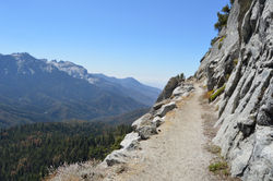 High in the Sierra |
 While in the Kern Hot Springs |
|---|
 Above Hamilton Lake |
 An Alpine Camp, West Side of Whitney |
 THE meadow of the BIG tree |
 A Big One |
West 2 East
 WHOA! |  Hamilton Lake afternoon |  Above hamilton lake |
|---|---|---|
 Walkin Thru a Tree |
 The BIG one |  Here and back and a bit more... |
|---|---|
 ValHalla |
bottom of page